2.6 million years ago – 57,000 years ago: Rocky Butte started as a Pleistocene basaltic andesite shield volcano within the Boring Lava Fields
14,000 years ago: Missoula floods happened. Today on the east side of Rocky Butte, Interstates 205 and 84 follow the broad channels carved by the floods. “… high velocities and turbulence induced by the submerged butte eroded huge scour pits on its upstream side; downstream, gravel bars many kilometers long were deposited. I-84 curves around the south and east sides of the butte in scour pits.”
Rocky Butte was originally called “Mowitch Illihee” which means “home of the deer” as evident by the presence of deer pits on the east side of the slope. The area around the butte was full of long houses of the Chinook-speaking bands of the Multnomah, Clackamas, and The Cascade-Watlala band of the Chinook.
1805: Lewis and Clark party canoed past Rocky Butte. The Columbia River basin experienced one of the highest population densities of the pre-contact Pacific Northwest. This area was full of long houses and homes of the Cascade-Watlala band of the Chinook speaking people, especially at the current location of the PDX airport. The uniquely diagonally streets of Sandy, Cully, and Foster are built upon old established Native American foot trails.
1840s-1960s: Rock Quarry and Railroads. The butte was also known as Wiberg Butte. Stone from the quarry was used to build:
- Union Pacific Railroad Bridges 1800s
- Portland Hotel 1882
- Penitentiary at Walla Walla 1886
- First Baptist Church 1892
- Steel Bridge 1912
- Westminster Presbyterian Church 1914
- Witch’s Castle in Forest Park 1930
- Canterbury Castle 1931
- Samuel Hill Monument, Portland Women’s Forum State Scenic Viewpoint Columbia Gorge 1932
- Loll Memorial 1936
- Col. Summers Park Monument 1938
- Rocky Butte Tunnel 1939
- NW Cornell Tunnels 1940
- Old Columbia Historic Highway restoration 1980s
- Numerous stone fireplaces in private homes across Portland
1920s: The Grotto and Shriners Children Hospital are built at the NE 82nd and Sandy Blvd. area. The natural rock formation was a shelter for Cascade/Watlala deer hunters before it was the Grotto and hospital.
1929: The rotating aircraft beacon is built on the summit and is one of the nation’s last remaining traces of the visual navigation system.
1931: The Hill Military Academy was built on Rocky Butte when relocated from NW Portland. Many graduates from the Academy went on to fight in WWI and WWII.
1930s: The Works Progress Administration (WPA) employed thousands of Portlanders to build the fortress viewpoint, scenic drive, tunnels and walls of Rocky Butte with local masons and craftsmen.
The magnificent stonework of the Rocky Butte area, similar to that of the Columbia River Highway, is fashioned from basalt quarried from the butte itself. The innovative tunnel, a 375 foot long switchback within the butte, was hand dug through solid lava.
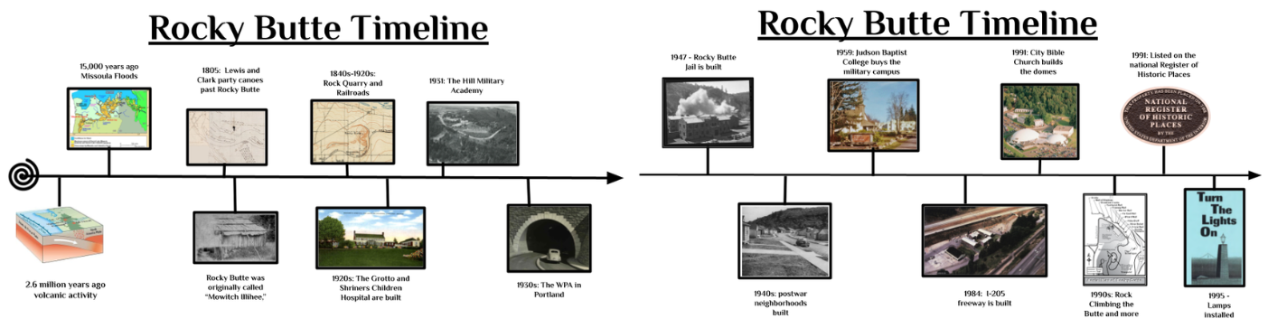
1947: Rocky Butte Jail is built directly from rocks of the butte quarry. The structure was built at the eastern base of the butte, currently where the Gateway Green bike park is, between I-205 and I-84 freeways.
1940s-1960s: Postwar neighborhoods are developed around the base of Rocky Butte. Madison South (previously known as Academy Heights) and other neighborhoods are built on hazelnut orchards, dairy farms, and grazing fields.
1959: Judson Baptist College buys the military campus and operates in the space until they relocate to The Dalles in 1980.
1984: I-205 freeway is built and the jail is deconstructed. The basalt stones are used in restoration projects of the Historic Columbia Highway in the Gorge.
1991: Rocky Butte Scenic Drive Historic District is listed on the National Register of Historic Places.
1991: City Bible Church builds the dome structures. During construction latex was inflated with air to support rebar and foam which was then sprayed with concrete. “Most everything was done with volunteers. Basically it was an inexpensive way to get a big piece of square footage.” Pastor Robert Jamison, of City Bible Church, was present in the construction in 1991, and recalls “getting maximum square footage for minimal budget without sacrificing energy efficiency was the reason for the unusual domed architecture. Interest rates were 20 percent at the time, you’re not getting a big loan.” In 2018, the church changed its name from City Bible Church to Mannahouse Church.
1995: Lamps are installed: For over 60 years the bastions were absent of lights until 1995 when the neighbors in the area advocated, organized and installed the 16 cast aluminum lamps. The lamps are modeled after the lights at Crown Point Visitors Center in the Columbia Gorge. In 1991 the Butte’s crest was listed under the National Register of Historic Places considering the aircraft beacon, recreational park, basalt stone parapet walls, 74 riser staircase, wide viewpoints, commemorative monuments, landmark viewfinder, scenic drive, pedestrian tunnel, and roadside bollards within the 21.48 acres.
1990s – present: Recreational hiking, cycling, trail running, rock climbing, weddings, beekeeping, Neander Games, Farmers’ Markets, RC Car driving, Geocaching and more.
